Display Settings
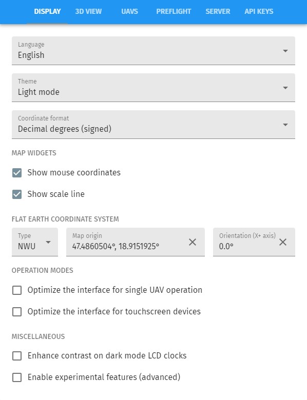
- Language
-
select the language of the frontend (note that translations are community-based, please visit our Weblate-based translation page to take part in translating Live into your own language as well).
- Theme
-
set light mode or dark mode depending on external light conditions
- Coordinate format
-
Setup how GPS coordinates should appear in the system
Map widgets
- Show mouse coordinates
-
Show or hide the GPS coordinate corresponding to the mouse coordinate when hovering over the map
- Show scale line
-
Show or hide the scale line on the map
Flat Earth coordinate system
- Type
-
Set the type of the relative coordinate system used on the map. Possible values are NEU (North-East-Up) and NWU (North-West-Up), these correspond to left- and right-handed relative coordinate systems with the positive x axis pointing towards North.
- Map origin
-
Set the absolute origin of the relative coordinate system on the map. Values for latitude and longitude are expected in degrees.
- Orientation
-
Set the rotation of the X+ axis of the relative coordinate system relative to North, in positive direction.
Operation modes
- Optimize the interface for single UAV operation
-
Clean up the user interface to single-UAV operations. This is mostly needed in industrial, mission-specific contexts, not for drone shows.
- Optimize the interface for touchscreen devices
-
Live can be run on many different platforms and also on many different device types. When you use a touchscreen, enable this checkbox to have a UX optimized for that.